
Download SRTM DEM Data for Bangladesh Using Google Earth Engine
📌 What is SRTM?
The Shuttle Radar Topography Mission (SRTM) provides global digital elevation data at 30-meter resolution. It’s one of the most widely used elevation datasets for terrain analysis, watershed modeling, and more.
🛠️ Step-by-Step: Clipping and Downloading SRTM for Bangladesh
Let’s walk through a simple GEE script that:
-
Loads the SRTM DEM.
-
Filters the country boundary for Bangladesh.
-
Clips the DEM to this boundary.
-
Displays the map.
-
Exports the result as a GeoTIFF to your Google Drive.
📜 Google Earth Engine Code
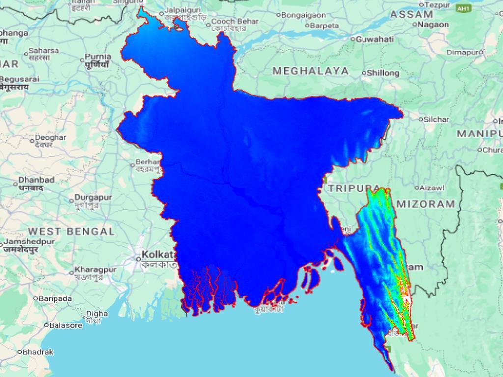
// Load the SRTM DEM
var srtm = ee.Image("USGS/SRTMGL1_003");

// Load country boundaries from GADM (Level 0)
var countries = ee.FeatureCollection("FAO/GAUL/2015/level0");

// Filter for Bangladesh
var bangladesh = countries.filter(ee.Filter.eq('ADM0_NAME', 'Bangladesh'));

// Center the map view on Bangladesh
Map.centerObject(bangladesh, 7);

// Add the boundary layer to the map
Map.addLayer(bangladesh, {color: 'red'}, 'Bangladesh');

// Clip the SRTM image to the boundary of Bangladesh
var srtmBangladesh = srtm.clip(bangladesh);

// Define visualization parameters
var visParams = {
  min: 0,
  max: 1000,
  palette: ['0000FF', '00FFFF', '00FF00', 'FFFF00', 'FF0000', 'FFFFFF']
};

// Add the DEM to the map
Map.addLayer(srtmBangladesh, visParams, 'SRTM DEM over Bangladesh');

// Export the clipped DEM to Google Drive
Export.image.toDrive({
  image: srtmBangladesh,
  description: 'SRTM_Bangladesh_DEM',
  folder: 'EarthEngineExports', // Change to your preferred folder
  fileNamePrefix: 'SRTM_Bangladesh',
  region: bangladesh.geometry(),
  scale: 30, // 30m resolution
  crs: 'EPSG:4326',
  maxPixels: 1e13
});
📤 How to Download the DEM
-
Open the Google Earth Engine Code Editor.
-
Paste the script into a new script window.
-
Click Run to load and view the DEM.
-
Open the "Tasks" tab (top-right corner).
-
Click "Run" on the export task.
-
Once processed, the DEM will be saved to your Google Drive in the folder you specified.
🌍 What Can You Do Next?
-
Open the GeoTIFF in QGIS or ArcGIS.
-
Overlay it with administrative boundaries or land cover maps.
-
Use it for flood mapping, terrain analysis, or watershed modeling.


0% Positive Review (0 Comments)